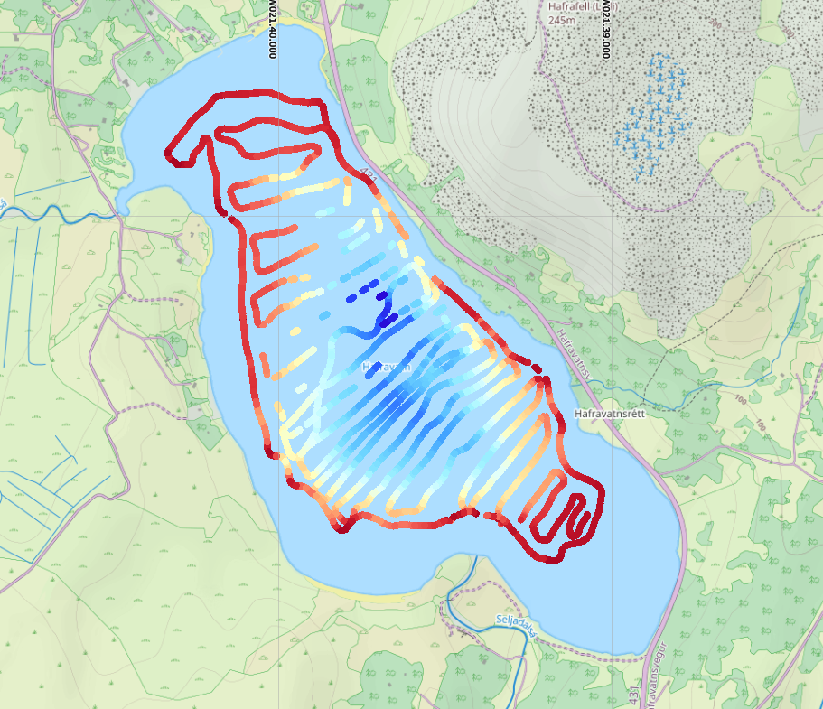
Kortlagning á dýpi Hafravatns fór fram 4. júlí 2024. Bátur og áhöfn frá skátunum í Mosfellsbæ (Mosverjar). Veður og hitastig var þokkalegt. Þó gerði nokkra norð/vestan átt sem olli nokkrum öldugangi úti á miðju vatninu.
Byrjað var að sigla jaðar vatnsins, til að finna minnsta siglingahæfa dýpið, sem væri u.þ.b 1 til 2 metra dýpi. Að því loknu var siglt frá NV til SV með óreglulegu millibili. Kortlagning hófst Úlfarsfellsmegin og endað í SA enda vatnsins (Þormóðsdalsmegin).
Mælingar voru gerðar með bergmálsdýptarmæli (Single Beam Sonar / 83 Khz og 200 Khz). Siglingin tók um 2,5 klst.
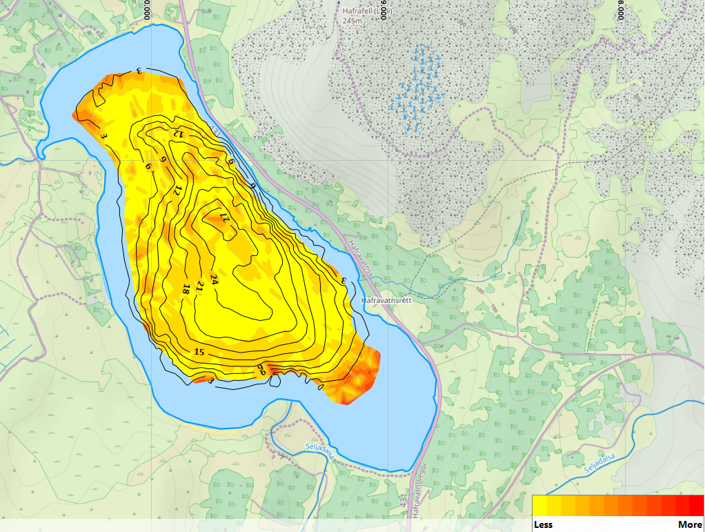
Jafnframt voru framkvæmdar tvígeislamælingar (Side Scan Sonar) af botninum, og gáfu þær kannanir nokkrar áhugaverðar niðurstöður, m.a. manngerðahluti á botninum sem þyrfti að skoða síðar.

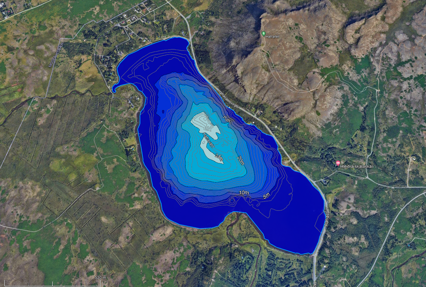

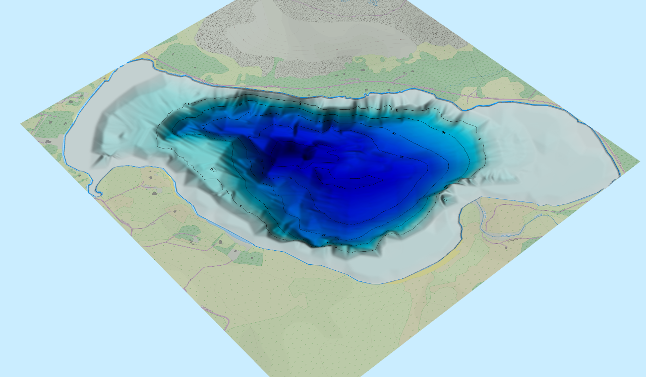
Dýptarkort af Hafravatni – Mesta dýpi 29 metrar, rauð merkt. Google Earth bakgrunnur. (Bathymetric map of Hafravatn. Maximum depth 29 meters. Google Earth layer). (DiveExplorer 07.2024)
(EN) „Google Translate“
Mapping of the depth of Hafravatn took place on July 4, 2024. Boat and crew from the scouts in Mosfellsbær (Mosverjar). The weather and temperature were decent. However, a north/westerly direction did, which caused some waves out in the middle of the lake.
We started sailing the edge of the lake, to find the smallest navigable depth, which would be approximately 1 to 2 meters deep. After that, we sailed from NW to SW at irregular intervals. Mapping started on the Úlfarsfell side and ended at the SA end of the lake (Þormóðsdal side).
Measurements were made with an echo sounder (Single Beam Sonar / 83 Khz and 200 Khz).
At the same time, side scan sonar measurements were carried out on the lake, and those surveys gave some interesting results, i.a. possible man made objects on the bottom that need further observations later.
Geography of Hafravatn
Information homepage: Guide to Iceland
Hafravatn is a relatively small lake. It is just over a kilometre squared, its deepest point is 28 meters (92 feet), and it sits 76 metres (249 feet) above sea level. It is, however, larger than its neighbouring lake, Langavatn, which sits to the southwest.
The lake is filled with water coming from the Seljadalsá River, which runs into its eastern side, and the river Úlfarsfellsá flows out of it. This river is named after the adjacent mountain Úlfarsfell, and the lake itself is named after another, Hafrafell.
As is the case in many of Iceland’s serene locations, there are several holiday homes surrounding Hafravatn, where locals retreat to get close to nature in summer. Until the seventies, there was a farm on site, as can be noted by the abandoned sheep pen against the lake’s shores.
Activities at Hafravatn
Due to its proximity to Reykjavík, Hafravatn is seen or featured on many tours and activities from the city. Of particular note are the many buggies and all-terrain vehicle excursions that leave the capital, which ascend the aforementioned mountains of Úlfarsfell and Hafrafell after circling the lake.
By Hafravatn is a launching site for paragliders, allowing guests to achieve incredible views of west Iceland, that includes the capital, Faxaflói bay, Mount Esjan, and the Snæfellsnes and Reykjanes Peninsulas, without ascending a mountain.
Finally, the lake is renowned for its fishing opportunities. Hafravatn is pregnant with many small arctic char, a delicacy in Iceland, and also home to the larger brown trout, which are caught on occasion.
Salmon have also been known to enter the lake from the river, but the area is not considered to be particularly good for salmon fishing compared to some other parts of the country.

Heimildir:

Færðu inn athugasemd