
Í gegnum árin höfum við staðið að fjölmörgum leitum að neðansjávarminjum, og stundað ýmsar neðansjávarrannsóknir og önnur verkefni.
Á þessum árum höfum við komið okkur upp smátt og smátt búnaði til að geta framkvæmt þessar leitir og verkefni.
Búnaður á borð við persónulegan köfunarbúnað, línuleitarkerfi, slöngubát, tvígeislamæli (e. Side Scan Sonar), neðansjávarmyndavélar (e. Underwater Camera Dive Sled) og neðansjávardróna (e. ROV „Remote Underwater Operated Vehicle“).
Hér gefur að líta ýmiss verkefni sem við höfum lokið, eru enn í vinnslu, eða í bið.
Eins og góðum ævintýramanni sæmir, þá eru sum verkefni þess eðlis og hafa verið í vinnslu, eða lokið ekki greind sérstaklega eða skýrt nánar frá. Að finna eða fá nákvæma staðsetningu er frekar ólíklegt að finna hér. 🙂


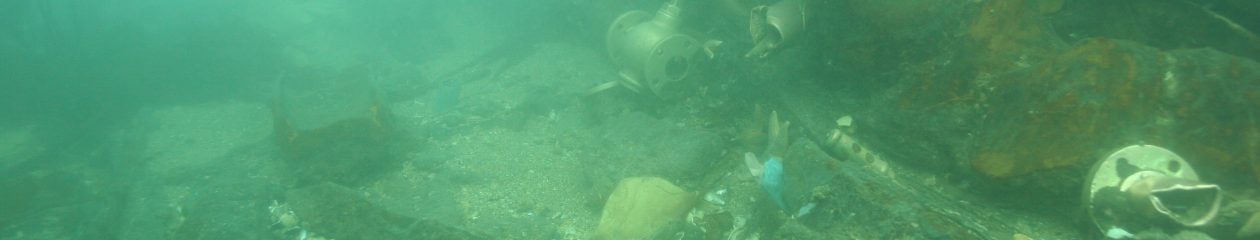
Könnunarleiðangur frávik 110
07. október 2023
Október veður eins og það gerist best. Sjórinn spegilsléttur og aðstæður með því allra besta til að fara í könnunarleiðangur.

Umrætt frávik kom fram í leiðangri 2015 og 2018. Á þeim tíma tókst okkur ekki að kanna hverskyns þetta frávik var. Nú var kominn tími til að bæta úr því. Lögðum af stað úr Kópavogshöfn um hádegisbilið og tók það okkur um það bil klukkustund til eina og hálfa að komast á staðinn. Þegar við vorum komnir á staðinn þýddi ekkert að bíða. Áhugi og spennan er alltaf til staðar um hvort væri að ræða nýtt skipsflak eða hvort umrætt frávik „target“ væri aðeins náttúrulegs eðlis.

Sjólagið eins og fyrr sagði var eins og myndirnar bera með sér, spegilslétt og lítill straumur þar sem við hittum akkurat á liggjandann.
Þrátt fyrir gott sjólag, og að veður hafði verið gott degi áður þá er það engin trygging að skyggni á þessum stað sé neitt að ráði. Reynsla okkar hefur sagt okkur það, þar sem við höfum verið að skoða önnur frávik og þar á meðal skipsflök ekki svo langt frá og vaninn hefur verið sá að skyggnið hefur verið lítið sem ekkert.
Líka þrátt fyrir að veður spili með þá er margt annað sem getur farið úrskeiðis eða bilað. Sem betur fer voru minniháttar vandamál sem komu upp í þessari ferð og tókst okkur nokkuð ágætlega upp.

Líklegast er um að ræða grjót, og steina sem eru þarna af náttúrulegum aðstæðum. Þó er alltaf möguleiki á að þetta sé ballast úr gömlu flaki en ekki var að sjá neitt manngert á staðnum. Ekki er úr myndinni að þetta frávik verði skoðað aftur.
Skyggni í sjónum var <1 meter. Dýpi 22 metrar, sjávarhiti ¨+10°C, enginn straumur. Leðju-leir botn. Köfunartími ROV 40 mínútur.
(EN)
Anomaly #110 – 7 October 2023
October weather is at its best. The sea is crystal clear and the conditions are the best for exploring.
The anomaly in question was observed during the 2015 and 2018 expeditions. At that time, we were unable to investigate what this anomaly was. Now it was time to fix it. We left Kópavogur port around noon and it took us about an hour to an hour and a half to get there. Once we got there, there was no point in waiting. There is always interest and excitement about whether it was a new shipwreck or whether the „target“ deviation was only natural.
The sea, as mentioned earlier, was as the pictures show, mirror smooth and a small current where we met exactly on the shore.
Despite the good sea conditions and the fact that the weather had been good the day before, there is no guarantee that the visibility at this place will be anything to go by. Our experience has told us that, as we have been looking at other anomalies including shipwrecks not so far away the habit has been that the visibility has been little to none.
Also, even though the weather plays a role, many other things can go wrong or fail. Fortunately, there were minor issues that arose on this trip and we managed quite well.
It is most likely rocks and stones that are there due to natural conditions. However, there is always the possibility that this is ballast from an old wreck, but nothing man-made could be seen on the spot. It is not out of the picture that this deviation will be examined again.
Visibility in the sea was <1 meter. Depth 22 meters, sea temperature ¨+10°C, no current. Mud-clay bottom. Dive time ROV 40 minutes.

July 2023 – Greenland AUV Recovery Mission
Not really a shipwreck expedition but….
Research vessel (R/V) Skagerak worked on a research study in the Sermilik fjord in Greenland in July 2024. Some of the research was done with a Hugin AUV „3000 m“(Autonomous Underwater Vehicle „Underwater Drone“)
In one of the missions, the AUV went into emergency failsafe mode and needed to surface. The Fjord was full of ice and Icebergs, and the AUV got stuck under one of the icebergs. So now was a time for a search and recovery operation.

Traveling to and from Greenland can be pretty complicated, especially if you have to fly with a lot of equipment, i.a. vulnerable stuff such as ROV „Remotely Operated Vehicle“ and diving equipment. Then go on foot or try to arrange a vehicle that can take all the equipment and bring it down to the dock, if there is a dock or harbor there. Then go by boat to meet a research vessel far into a Fjord with minimal electronic communication and internet connection available, except for some VHF and SAT-COM communications.
4. júní 2023 – ROV prófanir
Eftir samsetningar og uppfærslur á neðansjávarmyndavélinni eða ROV (e. Remotly Operated Vehicle) þennan vetur var ákveðið að skreppa aðeins út á sjó og athuga hvort allt virkaði ekki sem skildi fyrir þetta rannsóknarsumar.

Ákveðið var að fara stutt frá bænum og nýta þetta þokkalega sjólag og veður sem hefur verið að undanförnu. Byrjuðum við að fara á skipsflakið „H“ sjá hér. en við höfum undanfarin ár verið að rannsaka það og safna gögnum. Ávallt hefur verið aðstæður neðansjávar ekki verið þær bestu til slíkra rannsókna og þessi dagur var þar ekki undantekning, handónýtt skyggni. Þrátt fyrir það tókst okkur að finna flakið og prófa okkur áfram í ca. klukkustund. Áður en farið var á næsta stað og frekari prófanir gerðar á öðru flaki.

Í leiðangri árið 2015 fundum við þetta frávik en fram að þessu höfum við ekki náð að staðfesta hvort þetta sé skipsflak og þá mögulega hvaða. En nokkur koma til greina. Eftir þessar prófanir okkar þá getum við sannarlega staðfest að um skipsflak er að ræða. Við höfum grun um hvert og er það líklegast um 110 ára gamalt skipsflak um að ræða. Eins og sjá má á myndum er lítið sem ekkert skyggni en eftir greiningarvinnu á myndböndum og ljósmyndum má sjá klárlega spítnabrak af kjöl og ýmsum öðrum hlutum sem staðfestir sónar myndir, sem og önnur gögn sem við höfum aflað. Frekari rannsóknir framundan.
Dýpi 12m, hitatig sjávar +8° C.
Meira um þetta má finna hér á síðu um Skipsflakið „V“.
(AÞE / RE / HH / JKÞ)


_____________________________
Winter 2022 -2023
As the main expedition season is put on hold because of the winter it´s a good time for equipment maintenance and building new ones.
Here are two ROVs going through meticulous care maintenance, and upgrade.
Also, our old but trusted underwater camera dive sled will be getting a heavy upgrade as it is needed to handle extreme and rigorous missions where it needs to perform in high current water.
We hope that the year 2023 will give us some exciting adventures in our search for new shipwrecks and investigating others. Our list is quite long.


___________________________
Október 2022
Ávallt spennandi þegar ný skipsflök detta inn á sónarinn. Hér höfum við skipsflak sem við erum að rannsaka. Nokkrir leiðangrar hafa verið farnir (fjórir) en þeir hafa flestir verið ófullnægjandi og höfum við ekki náð að sinni að safna nægum gögnum.
Við höfum sterka hugmynd um hvaða skipsflak þetta er og verður það ekki gefið upp strax. Amk. ekki fyrr en staðfesting er komin og næg gögn og upplýsingar. Dýpið á þessum slóðum er um 40 metrar.
Það sem hægt er að gefa upp að svo stöddu er að það sökk á 20. öld, og því ekki fornminjar (fellur ekki undir fornminjalög. Aftur á móti það sem flækir hlutina, og því viljum við vera vissir um hvaða flak þetta er, því ekki ólíklega að það hafi orðið mannskaði þegar skipið sökk.
Við viljum vanda til verka þegar slíkt ber undir.


Hefurðu upplýsingar eða sögu um skipsflak / mannskaða sem þú vilt deila með okkur. Vantar þig upplýsingar sem gæti skipt máli, eða ekki um atburði út á sjó/vatni sem gæti varpað ljósi á skipsskaða. Hafðu samband og sendu tölvupóst. Ef um er að ræða trúnaðarmál, leyndó,, ekki málið, þess er vandlega gætt hér. diveexplorer@dive-explorer.com


(EN) Always exciting when new shipwrecks fall onto the sonar. Here we have a shipwreck that we are investigating. Several expeditions have been carried out (four), but most of them have been insufficient and we have not been able to collect enough data.
We have a strong idea of which shipwreck this is and it will not be released immediately. At least, not until confirmation has arrived and sufficient data and information.
What can be stated at the moment is that it sank in the 20th century, and therefore, is not an antiquities/protected (does not fall under antiquities law. On the other hand, what complicates things, and therefore we want to be sure, is that human casualties occurred when a ship sunk, i.e. in the case of the ship we suspect.
We want to work hard when this is necessary.
(EN-INFO) Do you have information about shipwrecks that you wanna share with us? Be in contact. If you need it to be a secret, no problem. Email us: diveexplorer@dive-explorer.com
More information here…………………..
_______________________________
September 2022 – Eyrarbakki
Eyrarbakki – Underwater Investigation.
For many years we have wanted to investigate the old harbor at Eyrarbakki.
Eyrarbakki was one of the oldest harbors in Iceland, as it was an old trading post/town from the Middle Ages to the 19th. Century.
Written documents and stories have been told about many shipwrecks around this old harbor.
We started the investigation with a Side Scan Sonar sweep. The weather was quite good for operating the boats and sonar. There are strong currents and powerful forces around the harbor. The depth becomes pretty deep, a short distance from the shore and many rocks, and underwater cliffs.
The preliminary investigation gives us a better understanding of the sea state, currents, underwater structure, etc., and possibilities for shipwrecks or the survival of other man-made objects.


_______________________________
July 2022 – Lake Þingvallavatn – Equipment tests

Constantly trying to tune and tweet the equipment for the underwater environment. Not often I can get the chance to test my equipment in Lake Thingvallavatn. But it is a great place to do so. It’s of course fresh water, cold, and pretty deep (+100m). So if there is a failure in the equipment the damage can be minimal compared to salt water. And also the recent accident in the lake taught me many things about searching and mapping the lake.

The test for the day was a new high-frequency side scan sonar, an underwater towed camera platform with a high-resolution video camera and lights.
______________________________
June 2021 – ROV testing
Out testing this ultra-compact ROV, Geneinno T1 Pro. What a piece of technology the specs for this underwater drone are excellent.. -175m depth rated, 6000-lumen lights, up to 4-8 hrs run time, and lots of accessories.. dive Exploring the underwater world has never become that easy, and affordable.


2010 – Patreksfjörður – Sonar mapping

Samantekt verkefna:
- 2006 – 2013: Póstskipið Phönix – leit + rannsókn
- 2010: Vestfirðir 2010 – Hljóðbylgjumælingar
- 2011: Pourquoi-Pas – Könnunarleiðangur / köfun
- 2013: Shipwreck Vega – Greenland Expedition
- 2015: Maríuhöfn / Hvalfjörður
- 2015 – 2019….: Skipsflakið „H“
- 2015: Ísafjarðardjúp – leit að skipsflaki
- 2016: Gautavík / Forn höfn á Austurlandi
- 2018: E/s Reykjavík – leit
- 2019: Landinn á RÚV – Verkefni + rannóknir
- 2020: Underwater survey 2020


